View All
Public Hearing Scheduled Regarding Proposed Salt Lick STAR Bond Development Projects

Click Resolution 2026-14 STAR BOND PROJECT PLANS (PDF) to view the entire resolution.
The public hearing is scheduled for June 24, 2026, at 9:00 a.m. in the Veterans Room at the Reno County Courthouse, 206 West 1st Avenue, Hutchinson, Kansas.
(Published in the Ninnescah Valley News on June 12, 2026)
RESOLUTION NO. 2026-14
A RESOLUTION OF RENO COUNTY, KANSAS, PROVIDING FOR NOTICE OF A PUBLIC HEARING TO CONSIDER ADOPTION OF CERTAIN STAR BOND PROJECT PLANS PURSUANT TO K.S.A. 12‑17,160 ET SEQ.
WHEREAS, pursuant to K.S.A. 12-17,160 et seq. (the “Act”), Reno County, Kansas (the “County”) is authorized to create a STAR bond project district within an eligible area of the County for certain purposes set forth in the Act; and
WHEREAS, pursuant to Resolution No. 26-12, adopted by the Board of County Commissioners (the “Governing Body”) May 13, 2026, and published May 15, 2026 (the “District Creation Resolution”), the County established a STAR bond project district known as the Salt Lick STAR Bond Project District (the “District”) to promote, stimulate and develop the general and economic welfare of the state of Kansas and the County as a major commercial entertainment and tourism area; and
WHEREAS, the County received from the Secretary of Commerce of the State of Kansas (the “Secretary”) a determination that the proposed Salt Lick STAR Bond Project District is an “eligible area” as said term is defined in the Act; and
WHEREAS, pursuant to the Act, the County is authorized to undertake one or more STAR Bond projects within the District, which may be implemented in separate development stages, and prepare a STAR Bond project plan, in consultation with the County’s planning commission; and
WHEREAS, the County is considering adoption of the “Salt Lick STAR Bond Project Plan 1,” the “Salt Lick STAR Bond Project Plan 2,” and the “Salt Lick STAR Bond Project Plan 3” (collectively, the “Project Plans”) submitted to the County on this date, which have been prepared in consultation with the County’s Planning Commission pursuant to the Act and provide for the redevelopment of all real property within the District (the “Project Areas”), as more particularly described on Exhibit A hereto; and
WHEREAS, on May 14, 2026, the County’s Planning Commission made findings that the Project Plans are consistent with the intent of the County’s comprehensive plan for the development of the County; and
WHEREAS, copies of the Project Plans were delivered by the County to the Board of Education of Unified School District No. 313, Reno County, Kansas (Buhler); and
WHEREAS, the Act provides that prior to adoption, the County shall, by resolution, call a public hearing to consider adoption of the Project Plans and shall give notice of said public hearing in accordance with the Act.
NOW, THEREFORE, BE IT RESOLVED BY THE GOVERNING BODY OF RENO COUNTY, KANSAS, AS FOLLOWS:
Section 1. Public Hearing. Notice is hereby given that the County shall conduct a public hearing to consider adoption of the Project Plans on June 24, 2026, at 9:00 a.m. or as soon thereafter as possible, in the Veteran’s Room at the Reno County Courthouse, 206 West 1st Avenue, Hutchinson, Kansas 67501. At the public hearing a representative of the County shall present the Project Plans, the County will receive public comment on the Project Plans, and after the conclusion of such public hearing, the County may adopt the Project Plans by Resolution adopted upon a 2/3rds vote of the County in accordance with the provisions of the Act.
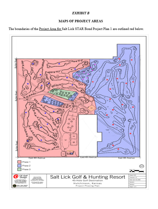
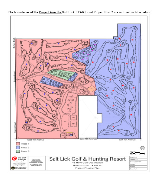
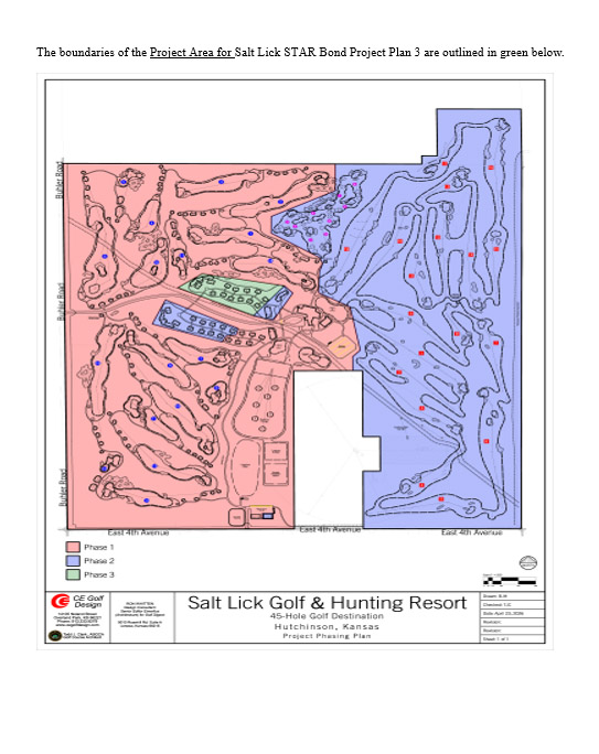
Section 2. STAR Bond Project Areas. Each Project Plan provides for the redevelopment of a Project Area, which consists of approximately 330.82 acres of land for the Salt Lick STAR Bond Project Plan 1, 279.67 acres of land for the Salt Lick STAR Bond Project Plan 2, and 8.90 acres of land for the Salt Lick STAR Bond Project Plan 3, all generally located west of N. Victory Road, north of E. 4th Avenue, east of Buhler Road, and south of E. 30th Avenue, including public rights of way adjacent thereto, all within the County. Maps generally outlining the boundaries of the Project Areas are attached hereto as Exhibit B.
Section 3. STAR Bond Project Plans. Each of the Project Plans for the redevelopment of the Project Areas may be described in a general way as a major commercial entertainment and tourism area that may include a mixed-use development consisting of some or all of the following uses: golf facilities, hunting facilities, lodging uses, restaurant uses, retail uses, general commercial development, and associated public and private infrastructure.
Each of the Project Plans to be considered by the County at the public hearing includes, but is not limited to: (a) a summary of the feasibility study required by the Act; (b) a reference to the District Plan as described in the District Creation Resolution; (c) a description and map of each of the Project Areas; (d) the relocation assistance plan as required by the Act; (e) a detailed description of the buildings and facilities proposed to be constructed or improved within each of the Project Areas; (f) the names of the owners, partners, officers or principals of any developer of the project and of any associated business partner of any developer of the project that is involved in each of the Project Plans; and (g) any other information the County deems necessary to advise the public of the intent of the Project Plans.
Section 4. Document Availability. Copies of each of the Project Plans, including a summary of the feasibility study, relocation assistance plan and any financial guarantees of the proposed developer and a description and map of each of the Project Areas to be redeveloped within the District are public records and are available for public inspection at the Reno County Courthouse, 206 West 1st Avenue, Hutchinson, Kansas 67501, during regular business hours.
Section 5. Notice. The County Clerk will give notice of the public hearing in accordance with the provisions of the Act, which include that a copy of this Resolution and Exhibits A and B attached hereto, will be:
(a) Provided via certified mail, return receipt requested, to the Board of Education of Unified School District No. 313, Reno County, Kansas (Buhler).
(b) Provided via certified mail, return receipt requested, to each owner and occupant of land within each of the proposed Project Areas not more than 10 days following the date of adoption of this Resolution.
(c) Published once in the official County newspaper not less than one week nor more than two weeks preceding the date fixed for the public hearing.
(d) Posted at a prominent location on the first page of the website of the County.
Section 6. Further Action. The Chair, County Administrator, and other officials and employees of the County, including the Reno County Counselor, and Gilmore & Bell, P.C., Bond Counsel, are hereby further authorized and directed to take such other actions as may be appropriate or desirable to accomplish the purposes of this Resolution.
Section 7. Effective Date. This Resolution shall be effective upon adoption by the County.
ADOPTED by the Board of County Commissioners of Reno County, Kansas on May 18, 2026.
_____/s/ Ron Hirst___________________
Ron Hirst, Chair
______/s/ Randy Parks________________
Randy Parks, Commissioner
_____/s/ Don Bogner__________________
Don Bogner, Commissioner
_____/s/ Ron Vincent_________________
Ron Vincent, Commissioner
____/s/ Richard Winger_______________
Richard Winger, Commissioner
Attest:
_____/s/ Jenna Fager___________________
Jenna Fager, County Clerk
CERTIFICATE
I hereby certify that the above and foregoing is a true and correct copy of the foregoing resolution of Reno County, Kansas, adopted by the County on May 18, 2026, as the same appears of record in my office.
DATED: May 18, 2026.
___/s/ Jenna Fager ____________________
Jenna Fager, County Clerk
EXHIBIT A
LEGAL DESCRIPTIONS OF THE PROJECT AREAS
Project Area for Salt Lick STAR Bond Project Plan 1
A portion of Section 9, Township 23 South, Range 4 West of the 6th Principal Meridian in Reno County, Kansas, more particularly described by Daniel E. Garber, Professional Survey #683, on May 4, 2026, as follows:
Beginning at the Southwest corner of the Southwest Quarter of Section 9, Township 23 South, Range 4 West of the 6th Principal Meridian; Thence with a bearing North 00°34’07” West (basis of bearings is NAD 83 Kansas South Zone) along the West line of said Southwest Quarter a distance of 2,683.68 feet to the Southwest corner of the Northwest Quarter of said Section 9; Thence North 00°34’22” West along the West line of said Northwest Quarter a distance of 2,640.57 feet to the Northwest corner of said Northwest Quarter; Thence South 89°51’09” East along the North line of said Northwest Quarter a distance of 2,664.79 feet to the Northwest corner of the Northeast Quarter of said Section 9; Thence South 89°54’20” East along the North line of said Northeast Quarter a distance of 497.02 feet; Thence South 00°20’34” West a distance of 388.50 feet; Thence South 63°11’07” West a distance of 831.42 feet; Thence South 00°16’40” West a distance of 241.76 feet; Thence South 57°41’22” East a distance of 662.55 feet; Thence South 24°23’08” East a distance of 96.46 feet; Thence South 18°43’34” West a distance of 122.56 feet; Thence South 01°37’17” West a distance of 310.34 feet; Thence South 60°42’55” East a distance of 417.44 feet; Thence South 10°32’58” East a distance of 641.50 feet; Thence South 42°26’06” West a distance of 130.29 feet; Thence South 00°24’01” East a distance of 203.89 feet; Thence South 89°51’42” West a distance of 686.65 feet to the East line of the Southwest Quarter of said Section 9; Thence South 00°12’32” East along the East line of said Southwest Quarter a distance of 2,300.00 feet to the Southeast corner of said Southwest Quarter; Thence South 89°51’56” West along the South line of said Southwest Quarter a distance of 2,631.72 feet to the point of beginning
EXCEPT A TRACT described as follows:
Commencing at the Southwest corner of the Northwest Quarter of Section 9, Township 23 South, Range 4 West of the 6th Principal Meridian; Thence with a bearing North 00°34’22” West (basis of bearings is NAD 83 Kansas South Zone) along the West line of said Northwest Quarter a distance of 837.76 feet; Thence South 89°51’09” East a distance of 1,316.24 feet for the point of beginning; Thence North 54°19’32” East a distance of 347.31 feet; Thence South 79°33’19” East a distance of 970.26 feet; Thence South 39°36’38” West a distance of 569.71 feet; Thence North 64°43’28” West a distance of 965.53 feet to the point of beginning
AND ALSO EXCEPT A TRACT described as follows:
Commencing at the Southwest corner of the Northwest Quarter of Section 9, Township 23 South, Range 4 West of the 6th Principal Meridian; Thence with a bearing North 00°34’22” West (basis of bearings is NAD 83 Kansas South Zone) along the West line of said Northwest Quarter a distance of 837.76 feet; Thence South 89°51’09” East a distance of 1,316.24 feet; Thence South 64°43’28” East a distance of 965.53 feet for the point of beginning; Thence North 39°36’38” East a distance of 569.71 feet; Thence South 42°20’14” East a distance of 144.54 feet; Thence South 29°54’26” West a distance of 455.57 feet; Thence North 74°55’50” West a distance of 241.74 feet to the point of beginning
AND ALSO EXCEPT A TRACT described as follows:
Commencing at the Southwest corner of the Northwest Quarter of Section 9, Township 23 South, Range 4 West of the 6th Principal Meridian; Thence with a bearing North 00°34’22” West (basis of bearings is NAD 83 Kansas South Zone) along the West line of said Northwest Quarter a distance of 306.56 feet; Thence South 89°51’09” East a distance of 1,013.86 feet for the point of beginning; Thence North 23°32’41” East a distance of 383.85 feet; Thence South 63°49’13” East a distance of 939.48 feet; Thence South 13°04’59” West a distance of 94.70 feet; Thence South 82°10’31” West a distance of 122.91 feet; Thence South 24°07’22” West a distance of 99.66 feet; Thence North 72°05’37” West a distance of 853.86 feet to the point of beginning
AND ALSO EXCEPT A TRACT described as follows:
Commencing at the Southeast corner of the Southwest Quarter of Section 9, Township 23 South, Range 4 West of the 6th Principal Meridian; Thence with a bearing South 89°51’56” West (basis of bearings is NAD 83 Kansas South Zone) along the South line of said Southwest Quarter a distance of 365.74 feet; Thence North 00°34’07” West a distance of 145.93 feet for the point of beginning; Thence North 00°08’04” West a distance of 86.00 feet; Thence North 89°51’56” East a distance of 120.00 feet; Thence South 00°08’04” East a distance of 86.00 feet; Thence South 89°51’56” West a distance of 120.00 feet to the point of beginning.
Project Area for Salt Lick STAR Bond Project Plan 2
A portion of Section 9, Township 23 South, Range 4 West of the 6th Principal Meridian in Reno County, Kansas, more particularly described by Daniel E. Garber, Professional Survey #683, on May 4, 2026, as follows:
Beginning at the Southeast corner of the Southeast Quarter of Section 9, Township 23 South, Range 4 West of the 6th Principal Meridian; Thence with a bearing South 89°51’32” West (basis of bearings is NAD 83 Kansas South Zone) along the South line of said Southeast Quarter a distance of 1,832.09 feet; Thence North 00°12’32” West a distance of 839.96 feet; Thence North 89°51’42´East a distance of 200.00 feet; Thence North 00°12’32” West a distance of 500.00 feet; Thence South 89°51’42” West a distance of 200.00 feet; Thence North 00°12’32” West a distance of 960.00 feet; Thence South 89°51’42” West a distance of 113.35 feet; Thence North 00°24’01” West a distance of 203.89 feet; Thence North 42°26’06” East a distance of 130.29 feet; Thence North 42°26’06” East a distance of 130.29 feet; Thence North 10°32’58” West a distance of 641.50 feet; Thence North 60°42’55” West a distance of 417.44 feet; Thence North 01°37’17” East a distance of 310.34 feet; Thence North 18°43’34” East a distance of 122.56 feet; Thence North 24°23’08” West a distance of 96.46 feet; Thence North 57°41’22” West a distance of 662.55 feet; Thence North 00°16’40” East a distance of 241.76 feet; Thence North 63°11’07” East a distance of 831.42 feet; Thence North 00°20’34” East a distance of 388.50 feet to the North line of the Northeast Quarter of said Section 9; Thence South 89°54’20” East along the North line of said Northeast Quarter a distance of 2,161.72 feet to the Northeast corner of said Northeast Quarter; Thence South 00°05’11” West along the East line of said Northeast Quarter a distance of 2,655.73 feet to the Northeast corner of the Southeast Quarter of said Section 9; Thence South 00°03’30” West along the East line of said Southeast Quarter a distance of 2,644.36 feet to the point of beginning containing 252.201 Acres
AND ALSO
A portion of the Southeast Quarter of Section 4, Township 23 South, Range 4 West of the 6th Principal Meridian in Reno County, Kansas, more particularly described by Daniel E. Garber, Professional Survey #683, on May 4, 2026, as follows:
Beginning at the Southeast corner of the Southeast Quarter of Section 4, Township 23 South, Range 4 West of the 6th Principal Meridian; Thence with a bearing North 89°54’20” West (basis of bearings is NAD 83 Kansas South Zone) along the South line of said Southeast Quarter a distance of 1,159.83 feet; Thence North 00°42’32” West a distance of 119.79 feet; Thence South 89°54’30” East a distance of 181.75 feet; Thence North 00°42’32” West a distance of 681.89 feet; Thence South 89°54’30” East a distance of 978.07 feet to the East line of said Southeast Quarter; Thence South 00°42’32” East along the East line of said Southeast Quarter a distance of 801.74 feet to the point of beginning containing 18.499 Acres
AND ALSO
A portion of Section 9, Township 23 South, Range 4 West of the 6th Principal Meridian in Reno County, Kansas, more particularly described by Daniel E. Garber, Professional Survey #683, on May 4, 2026, as follows:
Commencing at the Southwest corner of the Northwest Quarter of Section 9, Township 23 South, Range 4 West of the 6th Principal Meridian; Thence with a bearing North 00°34’22” West (basis of bearings is NAD 83 Kansas South Zone) along the West line of said Northwest Quarter a distance of 837.76 feet; Thence South 89°51’09” East a distance of 1,316.24 feet; Thence South 64°43’28” East a distance of 965.53 feet for the point of beginning; Thence North 39°36’38” East a distance of 569.71 feet; Thence South 42°20’14” East a distance of 144.54 feet; Thence South 29°54’26” West a distance of 455.57 feet; Thence North 74°55’50” West a distance of 241.74 feet to the point of beginning containing 2.158 Acres
AND ALSO
A portion of Section 9, Township 23 South, Range 4 West of the 6th Principal Meridian in Reno County, Kansas, more particularly described by Daniel E. Garber, Professional Survey #683, on May 4, 2026, as follows:
Commencing at the Southwest corner of the Northwest Quarter of Section 9, Township 23 South, Range 4 West of the 6th Principal Meridian; Thence with a bearing North 00°34’22” West (basis of bearings is NAD 83 Kansas South Zone) along the West line of said Northwest Quarter a distance of 306.56 feet; Thence South 89°51’09” East a distance of 1,013.86 feet for the point of beginning; Thence North 23°32’41” East a distance of 383.85 feet; Thence South 63°49’13” East a distance of 939.48 feet; Thence South 13°04’59” West a distance of 94.70 feet; Thence South 82°10’31” West a distance of 122.91 feet; Thence South 24°07’22” West a distance of 99.66 feet; Thence North 72°05’37” West a distance of 853.86 feet to the point of beginning containing 6.580 Acres
AND ALSO
A portion of Section 9, Township 23 South, Range 4 West of the 6th Principal Meridian in Reno County, Kansas, more particularly described by Daniel E. Garber, Professional Survey #683, on May 4, 2026, as follows:
Commencing at the Southeast corner of the Southwest Quarter of Section 9, Township 23 South, Range 4 West of the 6th Principal Meridian; Thence with a bearing South 89°51’56” West (basis of bearings is NAD 83 Kansas South Zone) along the South line of said Southwest Quarter a distance of 365.74 feet; Thence North 00°34’07” West a distance of 145.93 feet for the point of beginning; Thence North 00°08’04” West a distance of 86.00 feet; Thence North 89°51’56” East a distance of 120.00 feet; Thence South 00°08’04” East a distance of 86.00 feet; Thence South 89°51’56” West a distance of 120.00 feet to the point of beginning containing 0.237 Acres.
Project Area for Salt Lick STAR Bond Project Plan 3
A portion of Section 9, Township 23 South, Range 4 West of the 6th Principal Meridian in Reno County, Kansas, more particularly described by Daniel E. Garber, Professional Survey #683, on May 4, 2026, as follows:
Commencing at the Southwest corner of the Northwest Quarter of Section 9, Township 23 South, Range 4 West of the 6th Principal Meridian; Thence with a bearing North 00°34’22” West (basis of bearings is NAD 83 Kansas South Zone) along the West line of said Northwest Quarter a distance of 837.76 feet; Thence South 89°51’09” East a distance of 1,316.24 feet for the point of beginning; Thence North 54°19’32” East a distance of 347.31 feet; Thence South 79°33’19” East a distance of 970.26 feet; Thence South 39°36’38” West a distance of 569.71 feet; Thence North 64°43’28” West a distance of 965.53 feet to the point of beginning.